Highlights from the 9AM January 30, 2026 Winter Weather Briefing include
A winter storm arrives this weekend, starting late tonight and peaking Saturday evening through Sunday morning. 6-12” of snow is expected in SE VA and NE NC, with a sharp cutoff in snow totals to the northwest. Totals could go from 1” to 6”+ in less than 50 miles. Winter Storm Warnings have been issued for SE VA/NE NC where confidence in heavy snow is highest, and watches remain in effect farther NW (including the Richmond Metro) where uncertainty is higher and/or totals have trended down.
Strong winds are likely with this storm, especially along the coast where winds may be damaging. Blizzard conditions are possible with the greatest chance along the coast.
Very cold wind chills are expected beginning tonight and continuing into Sunday with the coldest wind chills Saturday night into early Sunday where wind chills below 0F are possible area-wide. Cold Weather Advisories are in effect from tonight into early Saturday night with Extreme Cold Watches in effect from Saturday night into Sunday morning.
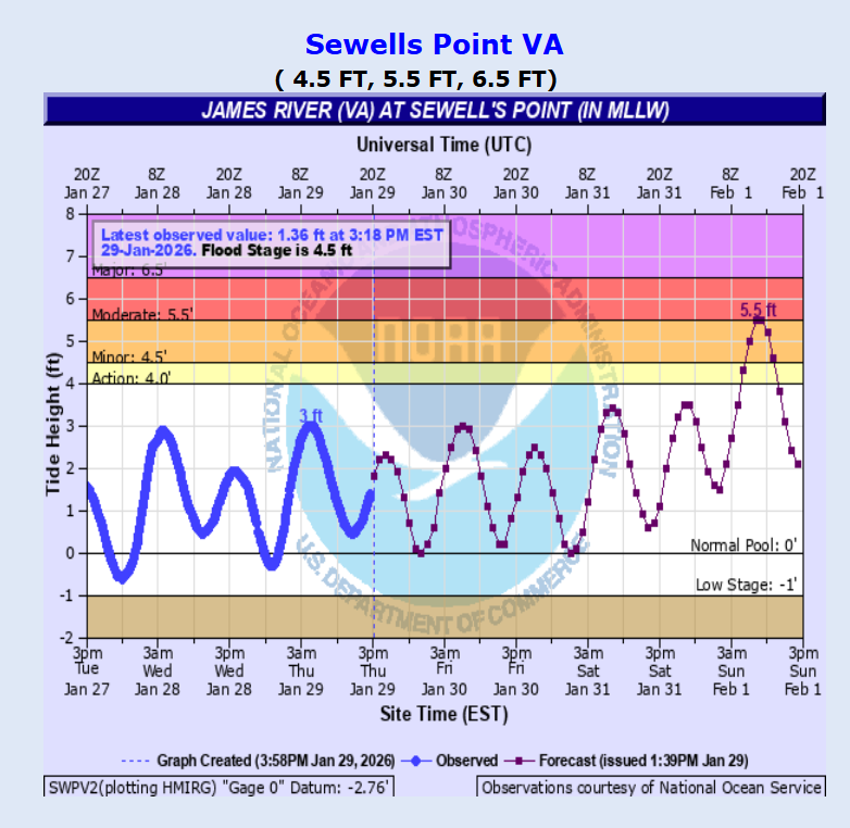
Tidal flooding is likely Saturday night into Sunday. Moderate to locally major tidal flooding is possible, especially in the lower Chesapeake Bay. Beach and dune erosion are likely on Sunday. Due to very cold temperatures, any tidal flooding could freeze to road surfaces. Coastal Flood Watches are in effect for Norfolk/Chesapeake, VA Beach, Northampton County VA and Eastern Currituck County.
Marine Weather - Storm Warnings have been issued for the coastal waters south of Cape Charles from Sat night-Sun, and Storm Watches remain in effect for the bay, Lower James, and northern coastal waters. Small Craft Advisories are in effect today. Heavy Freezing Spray Watches have been issued for the bay, Lower James, and northern coastal waters from Sat night-Sun AM.
To view the full briefing from the National Weather Service visit https://www.weather.gov/media/akq/briefings/LatestBriefing.pdf
The high tide at Messick Point for Sunday is forecasted for 8:29AM and is expected to be in the moderate flood stage range.